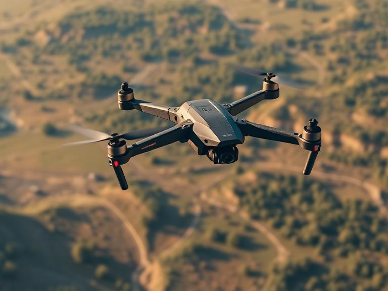
In the rapidly advancing field of geospatial intelligence, 2026 marks a pivotal year for autonomous surveying. As industries shift from manual data collection to high-speed digital twinning, the demand for the best UAV aerial mapping fixed wing platforms has reached an all-time high. These aircraft, bridging the gap between traditional satellites and short-range multirotors, offer the endurance and precision necessary for modern infrastructure and agricultural management.
The following guide explores the top-tier fixed-wing and VTOL (Vertical Take-Off and Landing) solutions currently dominating the market, with a special focus on the heavy-lift and bionic innovations from China Moneypro.
Table of Contents
- 1. The Evolution of Mapping: Why Fixed-Wing Wins in 2026
- 2. Featured Innovations: China Moneypro Solutions
- 3. Top 10 Best UAV Aerial Mapping Fixed Wing Drones
- 4. Advanced Sensor Integration: 2D, 3D, and LiDAR
- 5. Technical Comparison Table
- 6. Choosing Your Mapping Platform: A Buyer’s Guide
- 7. Frequently Asked Questions (FAQs)
- 8. References and Industry Standards
1. The Evolution of Mapping: Why Fixed-Wing Wins in 2026
Aerial mapping has undergone a radical transformation. While multirotors are excellent for small-scale inspections, they lack the aerodynamic efficiency required for large-scale geospatial data collection. The best UAV aerial mapping fixed wing platforms utilize airfoils to generate lift, allowing them to cover up to ten times the area of a standard drone in a single flight.
In 2026, the industry has standardized on VTOL (Vertical Take-Off and Landing) technology. This hybrid approach eliminates the need for runways or catapult launchers, allowing a fixed-wing aircraft to rise vertically like a helicopter before transitioning into high-speed horizontal flight. This capability is crucial for missions in rugged terrain, dense forests, or confined urban construction sites where traditional landing strips are unavailable.
2. Featured Innovations: China Moneypro Solutions
China Moneypro has emerged as a disruptive force in the 2026 market, offering hardware that balances extreme endurance with intelligent flight controls. Their systems are specifically designed for the high-precision requirements of the modern surveyor.
Moneypro MVT240 PRO Bionic VTOL Drone
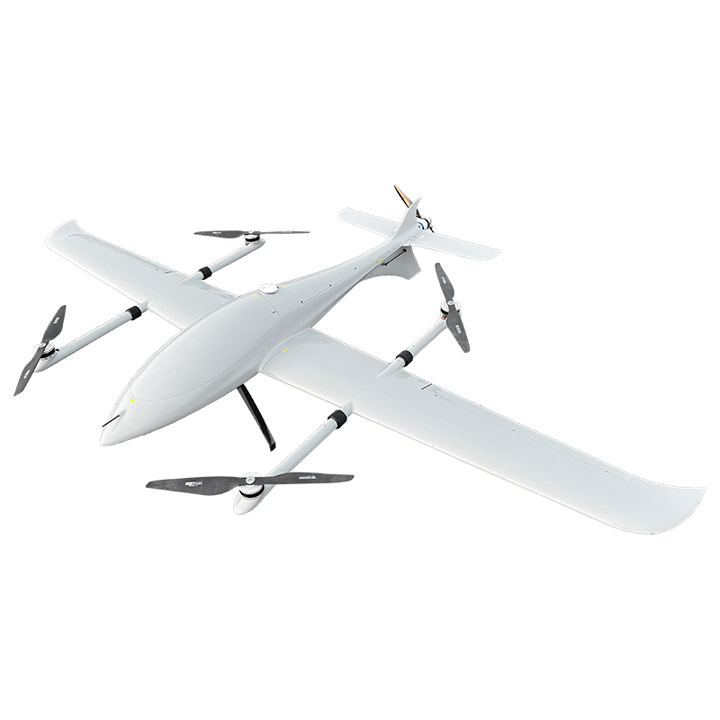
The MVT240 PRO features a high-lift airfoil with a conventional 4+1 configuration, boasting a high lift-to-drag ratio and exceptional flight performance. It offers a 1.6kg payload capacity—providing ample space for equipment installation—and an ultra-long endurance of 3.5 hours. Notably, it combines the advantages of multirotor systems, such as vertical takeoff and landing (VTOL), with the long endurance, low noise, and reconnaissance capabilities inherent to fixed-wing aircraft.
Constructed entirely from carbon fiber, the MVT240 PRO achieves a lightweight build without compromising structural strength. Its advanced aerodynamic layout ensures smooth, stable flight while effectively reducing air resistance and power consumption. A key highlight is its unique tail wing, which is designed as an elevator; this innovative design significantly enhances the aircraft’s lift. For 2D and 3D mapping purposes, the MVT240 PRO is recommended to be paired with orthographic cameras and the oblique photography camera (VO-120S).
Moneypro M380 Heavy Lift Hybrid VTOL
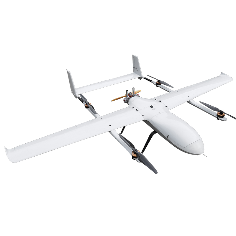
For large-scale industrial missions, the M380 represents the pinnacle of heavy-lift fixed-wing technology. With a massive 3.8m wingspan and an EFI (Electronic Fuel Injection) engine, it is built for missions that require both weight and distance. It features a standard 10kg load capacity (max 15kg) and an endurance of 4 hours, making it the best UAV aerial mapping fixed wing for corridor mapping and border patrol.
The M380 utilizes dual-RTK positioning for 0.01m accuracy and features advanced flight intelligence with 1,000-waypoint automatic routing. Its modular detachable design allows for assembly in just 3 minutes, despite its large frame.
3. Top 10 Best UAV Aerial Mapping Fixed Wing Drones
1. China Moneypro M380 Hybrid
The ultimate heavy lifter. Its 4-hour endurance and 10kg payload make it ideal for carrying high-end LiDAR sensors and multi-sensor arrays over vast forest reserves or national borders.
2. WingtraOne Gen II
A favorite for mid-range commercial surveying. Its unique “tailsitter” design allows it to take off on its tail and flip into forward flight. It is renowned for its 42MP Sony RX1R II integration, providing survey-grade accuracy without ground control points (GCPs).
3. China Moneypro MVT240 PRO
The best choice for high-precision bionic flight. Its carbon fiber construction and 3.5-hour flight time make it an incredibly efficient platform for environmental monitoring and 3D urban reconstruction.
4. Quantum-Systems Trinity Pro
A German-engineered eVTOL that excels in ease of use. The Trinity Pro is known for its proprietary QBase 3D software, which simplifies mission planning for complex topographic surveys.
5. AgEagle eBee X
The industry standard for lightweight fixed-wing mapping. While it requires a belly land, its regulatory “Blue UAS” status makes it the preferred choice for US government and military mapping projects.
6. JOUAV CW-25E
A high-performance electric VTOL designed for long-range missions. It is frequently used in China and Southeast Asia for powerline inspection and large-scale agricultural mapping.
7. Autel Dragonfish Standard
Autel’s flagship VTOL offers a unique tilt-rotor design. It is highly valued for its 4K 50x optical zoom gimbal, which allows for reconnaissance alongside mapping missions.
8. Vertical Technologies DeltaQuad Pro
An open-source friendly platform that offers one of the highest endurance-to-weight ratios in the electric VTOL category. It is a top choice for R&D teams and custom sensor integration.
9. Harris Aerial Carrier H6
While often seen as a multirotor, the H6 Hybrid version utilizes fixed-wing principles for transit, providing a versatile platform for users who need both hover-heavy inspection and distance mapping.
10. FlyTech Birdie
A compact, professional-grade mapping drone that can be hand-launched. It is the best UAV aerial mapping fixed wing for teams that need to hike into remote locations with a lightweight, backpackable solution.
4. Advanced Sensor Integration: 2D, 3D, and LiDAR
A mapping drone is only as good as the data it captures. In 2026, the best UAV aerial mapping fixed wing platforms are expected to support a variety of interchangeable payloads:
- Oblique Photography: Like the VO-120S used with the Moneypro MVT240 PRO, these cameras capture images from multiple angles to create hyper-realistic 3D meshes.
- LiDAR (Light Detection and Ranging): Essential for mapping terrain beneath dense vegetation. LiDAR sensors on heavy lifters like the M380 can penetrate forest canopies to reveal the ground surface.
- Multispectral Imaging: Critical for precision agriculture. These sensors detect “invisible” light bands to assess crop health and soil moisture.
- RTK/PPK Modules: Integrated Real-Time Kinematic positioning ensures that every image is geotagged with centimeter-level precision, reducing the need for manual ground markers.
5. Technical Comparison Table
| Model | Endurance | Max Payload | Wingspan | Best Feature |
|---|---|---|---|---|
| Moneypro M380 | 4.0 Hours | 15 kg | 3.8 m | Heavy Lift / EFI Engine |
| MVT240 PRO | 3.5 Hours | 1.6 kg | 2.4 m | Bionic Carbon Fiber Build |
| WingtraOne II | 59 Mins | 0.8 kg | 1.25 m | High-Res Photogrammetry |
| eBee X | 90 Mins | 1.6 kg | 1.16 m | Regulatory Compliance |
| Trinity Pro | 90 Mins | 0.7 kg | 2.39 m | Modular Payload System |
6. Choosing Your Mapping Platform: A Buyer’s Guide
To identify the best UAV aerial mapping fixed wing for your specific needs, consider the following environmental and operational factors:
Operating Altitude and Terrain
If your projects are located in high-altitude regions (above 3,000m), you require a high-thrust system like the Moneypro M380, which is rated for operation at 4,000m. Standard electric drones often struggle with thin air, leading to reduced endurance and stability.
Accuracy Requirements
For cadastral surveying (land ownership), centimeter-level accuracy is mandatory. Look for Dual-RTK positioning systems. If you are only performing volumetric measurements for mining, a slightly lower precision might be acceptable in exchange for a longer flight time.
Deployment Speed
In emergency response or rapid reconnaissance, the time it takes to assemble the aircraft is vital. The M380’s 3-minute tool-less assembly is the gold standard for rapid deployment in the field.
7. Frequently Asked Questions (FAQs)
Is a fixed-wing drone harder to fly than a quadcopter?
Traditionally, yes. However, modern 2026 flight controllers and VTOL technology have made them virtually autonomous. Pilots now focus on mission planning rather than manual stick-and-rudder control.
Can fixed-wing mapping drones fly in high winds?
Fixed-wing aircraft are generally more stable in high winds than multirotors due to their aerodynamic shape. High-performance models like the MVT240 PRO can maintain steady flight even in moderate gusts that would ground a standard quadcopter.
What software is needed for mapping?
Most professionals use Pix4D, Agisoft Metashape, or SimActive Correlator3D. These programs take the raw images from your fixed-wing UAV and stitch them into orthomosaics and 3D models.
Do I need a special license for a 3.8m wingspan drone?
Yes. In most jurisdictions, including under FAA Part 107 or EASA regulations, drones over 25kg require additional waivers and certifications. Always check local laws regarding heavy-lift UAV operations.