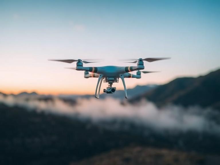
In the rapidly advancing fields of geospatial surveying, agriculture, mining, and civil engineering, professionals constantly seek the most efficient methods for large-scale data acquisition. A question that frequently arises in our consultations is: Are fixed-wing drones good for mapping? As experts at ChinaMoneypro UAV, we can definitively state that they are not just good; they are the absolute industry standard for expansive, high-precision aerial surveying.
ChinaMoneypro UAV is a national-level high-tech enterprise, transformed from a prestigious state-owned research institute. With deep roots in defense-grade engineering, we specialize in the R&D and manufacturing of advanced unmanned platforms and integrated sensing-communication solutions. Headquartered in one of China’s premier innovation hubs, ChinaMoneypro UAV is among the few full-stack providers offering complete UAV systems, engines, gimbals, radar, data links, and communication technologies. From our experience, when clients ask Are fixed-wing drones good for mapping, they are usually weighing the benefits of aerodynamic lift against the hovering capabilities of standard multirotors. In this comprehensive guide, we will dissect the mechanical, aerodynamic, and operational advantages of fixed-wing platforms and demonstrate why they dominate the professional mapping sector.
Table of Contents
- Summary Table: Mapping Drone Comparison
- The Science of Aerodynamics in Aerial Mapping
- Endurance and Area Coverage Capabilities
- The Hybrid VTOL Revolution in Surveying
- ChinaMoneypro UAV Professional Mapping Solutions
- Payload Integration: Sensors, RTK, and LiDAR
- The Importance of Defense-Grade Data Links
- Cost-Benefit Analysis and ROI
- Frequently Asked Questions
- Industry References
Summary Table: Mapping Drone Comparison
To immediately address the core question, Are fixed-wing drones good for mapping, we have provided a technical comparison between traditional multirotors, pure fixed-wings, and our highly recommended Hybrid VTOL (Vertical Take-Off and Landing) fixed-wing platforms.
| Feature / Capability | Standard Multirotor | Traditional Fixed-Wing | Hybrid VTOL Fixed-Wing |
|---|---|---|---|
| Primary Advantage | Hovering precision, cheap | Flight endurance, speed | Endurance combined with vertical launch |
| Flight Time | 30 to 55 minutes | 2 to 4 hours | 3.5 to 10+ hours |
| Mapping Coverage (per flight) | Under 100 hectares | 500 to 1,000 hectares | 1,000 to 5,000+ hectares |
| Launch & Recovery Area | Small (3×3 meters) | Large (requires runway or catapult/parachute) | Small (3×3 meters) |
| Are fixed-wing drones good for mapping? | No, highly inefficient for large areas | Yes, but logistically difficult to launch | Yes, the ultimate professional standard |
The Science of Aerodynamics in Aerial Mapping
To truly understand Are fixed-wing drones good for mapping, one must look at the physics of flight. Multirotor drones expend an enormous amount of battery power simply fighting gravity to stay airborne. Their rotors must continuously push air downward to maintain altitude, leaving very little energy reserve for forward propulsion. Conversely, fixed-wing aircraft utilize the Bernoulli principle. The shape of the wings generates natural lift as the aircraft moves forward, meaning the motor only needs to overcome aerodynamic drag, not the total weight of the aircraft.
From our experience in defense-grade engineering, this fundamental difference in aerodynamics translates to extreme efficiency. When conducting photogrammetry or LiDAR mapping, the drone must fly in strict grid patterns over vast areas. The aerodynamic glide ratio of a fixed-wing platform ensures that it consumes a fraction of the power per kilometer compared to a multirotor, making the answer to Are fixed-wing drones good for mapping an undisputed yes for corridor mapping, pipeline inspections, and large-scale topography.
Endurance and Area Coverage Capabilities
Time is the most expensive variable in surveying. When potential operators ask us, Are fixed-wing drones good for mapping, we immediately point to area coverage metrics. A standard quadcopter might cover 50 hectares before requiring a battery swap. This necessitates the surveying crew to carry dozens of batteries, deploy multiple launch points, and spend hours stitching together fragmented data sets, which introduces severe geometric distortion risks.
A professional fixed-wing platform solves this bottleneck. Because of their aerodynamic efficiency, they can stay aloft for several hours. This allows surveyors to map thousands of hectares in a single, uninterrupted flight. The continuous data collection ensures consistent lighting conditions for photogrammetry and seamless trajectory data for PPK/RTK processing. We recommend fixed-wing platforms for any project exceeding 200 hectares.
The Hybrid VTOL Revolution in Surveying
Historically, when people asked Are fixed-wing drones good for mapping, the primary counter-argument was launch and recovery logistics. Traditional fixed-wing drones required bulky catapult launchers, long runways, or risky belly landings that frequently damaged expensive payload sensors. ChinaMoneypro UAV has eliminated this drawback through advanced Hybrid VTOL technology.
Hybrid VTOL aircraft possess dedicated vertical lifting motors, allowing them to take off and land like a helicopter in confined spaces. Once at the designated altitude, the aircraft transitions to forward horizontal flight using a pusher motor, relying on its wings for lift. This marries the operational flexibility of a multirotor with the unmatched endurance of a fixed-wing. From our experience, the VTOL transition is the most critical phase of flight, requiring sophisticated flight controllers developed through our defense-grade research institute background.
ChinaMoneypro UAV Professional Mapping Solutions
We do not just answer the question, Are fixed-wing drones good for mapping; we build the hardware that proves it. As a full-stack provider, our aircraft are engineered for absolute reliability in hostile environments.
China Moneypro MVT390 Super Powerful Hybrid VTOL Drone with Robust 3.9m Wingspan 10hrs Flight Time
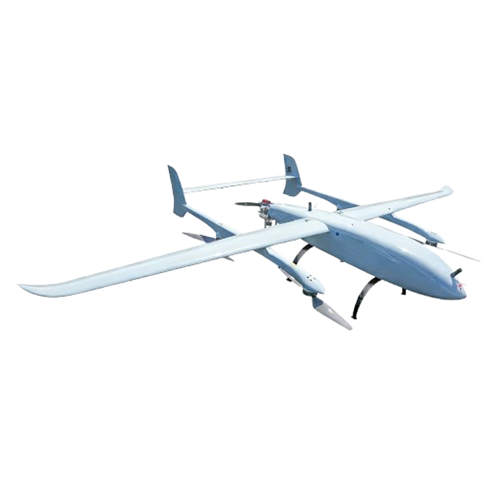
For massive infrastructure projects, border mapping, and extensive agricultural surveying, the China Moneypro MVT390 Super Powerful Hybrid VTOL Drone with Robust 3.9m Wingspan 10hrs Flight Time is our flagship solution. This platform single-handedly answers Are fixed-wing drones good for mapping by providing an unprecedented 10 hours of flight endurance. Equipped with a highly efficient hybrid power system, the 3.9-meter wingspan offers a massive glide ratio and stability in high-wind conditions. We recommend the MVT390 for operators who require the integration of heavy LiDAR systems or dual-sensor payloads. Its VTOL capability ensures that this massive aircraft can be deployed from small jungle clearings or rugged mountainous terrain without a runway.
China Moneypro MVT240 PRO Bionic VTOL Drone Smooth Flight UAV max 1.6kg Payload 3.5hrs Endurance
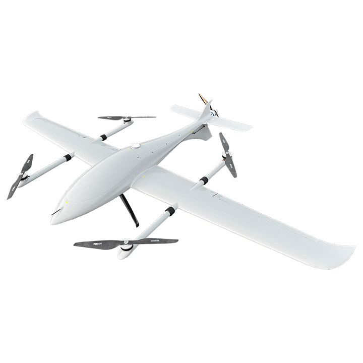
For rapid deployment and high-precision photogrammetry, the China Moneypro MVT240 PRO Bionic VTOL Drone Smooth Flight UAV max 1.6kg Payload 3.5hrs Endurance is the optimal choice. This bionic design reduces aerodynamic drag significantly, ensuring a remarkably smooth flight trajectory which is critical for reducing motion blur in high-resolution orthomosaic mapping. With a 1.6kg payload capacity, it easily carries full-frame mapping cameras or specialized multispectral sensors. The 3.5-hour endurance allows for the complete mapping of municipal districts or large mining sites in a single deployment, firmly establishing why Are fixed-wing drones good for mapping remains an undeniable fact in modern surveying.
Payload Integration: Sensors, RTK, and LiDAR
The aircraft is only a delivery vehicle for the sensor. Are fixed-wing drones good for mapping when carrying heavy payloads? Absolutely. The robust design of our platforms allows for the seamless integration of professional-grade sensors. To achieve survey-grade accuracy (often down to 1-3 centimeters), our platforms utilize Real-Time Kinematic (RTK) and Post-Processed Kinematic (PPK) GNSS positioning. This eliminates the need for laying out dozens of time-consuming Ground Control Points (GCPs).
Furthermore, because ChinaMoneypro UAV is a full-stack provider offering complete UAV systems, engines, gimbals, and radar, we ensure that the communication protocols between the flight controller and the mapping payload are perfectly synchronized. Whether you are deploying a high-density LiDAR puck for forestry canopy penetration or an oblique camera system for 3D city modeling, the stability of the fixed-wing flight path guarantees superior data integrity.
The Importance of Defense-Grade Data Links
When executing a mapping mission 50 kilometers away from the launch site, consumer-grade radio links will fail. To fully realize why Are fixed-wing drones good for mapping, you must possess absolute control and telemetry monitoring at extreme Beyond Visual Line of Sight (BVLOS) distances. Our heritage as a national-level high-tech enterprise ensures that our communication technologies are highly resistant to electromagnetic interference. We provide robust data links that guarantee real-time video transmission and uninterrupted flight telemetry, ensuring the safety of the aircraft and the success of the mapping mission.
Cost-Benefit Analysis and ROI
Ultimately, procurement decisions are driven by Return on Investment. Are fixed-wing drones good for mapping budgets? Yes. While the initial capital expenditure for a system like the China Moneypro MVT390 is higher than a commercial multirotor, the operational cost per hectare drops dramatically. By completing jobs in hours rather than weeks, surveying companies can bid on larger contracts, reduce personnel field time, and deliver actionable data to clients exponentially faster. The reduction in labor and logistical costs ensures a rapid ROI, making fixed-wing VTOL platforms the most financially sound choice for serious geospatial organizations.
Frequently Asked Questions
While Are fixed-wing drones good for mapping large areas is an established fact, for ultra-small sites (under 10 hectares), a multirotor may be more practical due to its ability to hover and take extremely low-altitude, high-overlap images of a single building. However, for anything larger, a VTOL fixed-wing like the China Moneypro MVT240 PRO is far more efficient.
VTOL mechanisms add slight weight (extra lifting motors and arms) to the aircraft, which marginally reduces the maximum payload compared to a pure catapult-launched fixed-wing. However, from our experience, the safety of vertical landings completely negates this minor trade-off, saving tens of thousands of dollars in preventing damaged mapping sensors during rough belly landings.
Yes. Fixed-wing drones generally have higher wind resistance than multirotors because they dynamically slice through the air rather than fighting it purely with motor RPM. Our platforms, resulting from defense-grade engineering, are designed to maintain stable flight attitudes even in challenging weather conditions, ensuring crisp, blur-free photogrammetry.
Consumer brands rely on mass-market, closed-ecosystem components. ChinaMoneypro UAV is a full-stack provider offering defense-grade engineering. When you need reliability, 10-hour endurances, and specialized radar and communication technologies, our industrial platforms provide unmatched security and operational capability for professional surveying.
Industry References and Technical Methodology
- International Society for Photogrammetry and Remote Sensing (ISPRS): Guidelines for BVLOS Large-Scale Topographic Mapping.
- Global GNSS Accuracy Standards: Utilizing PPK/RTK in High-Speed Aerial Surveying.
- State-Owned Research Institute Defense Protocols applied to Commercial UAV Data Link Security.