Industries that rely on precise geospatial intelligence increasingly turn to the fixed wing UAV for mapping as their preferred aerial platform. Their superior endurance, long-range capability, and large-area coverage make them the most efficient tools for surveying, construction planning, environmental monitoring, corridor inspections, and emergency response.
This comprehensive guide ranks the top 8 fixed wing UAV for mapping based on performance, payload support, range, reliability, and professional survey readiness. It also includes a detailed spotlight on ChinaMoneypro UAV — one of the world’s rising leaders in high-performance unmanned systems.
Table of Contents
Why Choose a Fixed Wing UAV for Mapping?
A fixed wing UAV for mapping offers key advantages over multirotor drones, especially when covering large terrain or performing long-endurance missions. Engineers, surveyors, and GIS professionals overwhelmingly prefer fixed wing hybrid platforms when the objective is to collect high-resolution, large-format geospatial data efficiently.
Key Advantages
- Longer flight endurance — fly 1 to 5 hours depending on configuration.
- Greater mapping coverage — some models exceed 20 km² per flight.
- Higher flight speed — enabling rapid data capture in tight project timelines.
- Superior efficiency — fixed-wing aerodynamics require less energy than multirotors.
- Better performance at high altitude — ideal for mountainous or remote regions.
These benefits make the fixed wing UAV for mapping the gold standard for large-scale surveys and professional-grade photogrammetry missions.
Company Spotlight: ChinaMoneypro UAV
ChinaMoneypro UAV is a national-level high-tech enterprise transformed from a prestigious state-owned research institute. With deep defense-grade engineering roots, the company specializes in advanced unmanned platforms and integrated sensing-communication solutions. Headquartered in one of China’s premier innovation hubs, Moneypro is among the few full-stack providers offering complete UAV systems, engines, gimbals, radar, data links, and communication technologies.
This engineering depth allows Moneypro’s UAV systems to deliver exceptional reliability, stability, and sensor integration — qualities crucial for mission-critical mapping applications.
Product Spotlight: Moneypro Fixed Wing UAV for Mapping
1. Moneypro 15KG Spring Knife Fixed Wing UAV

| Parameter | Specification |
|---|---|
| Max Takeoff Weight | 15.5 kg |
| Flight Speed | 140–160 km/h |
| Range | >120 km |
| Operating Altitude | 100 m – 3000 m |
| Flight Endurance | ≥ 60 min |
| Communication Distance | ≥ 30 km |
| Payload Capacity | 4.5 kg |
| Wingspan | ≥ 1800 mm |
| Operating Temperature | -20°C to +50°C |
Ideal for rugged deployments, long-range mapping, and industrial corridor inspection, the Spring Knife stands out for its powerful motor, aerodynamic efficiency, and large payload bay that supports LiDAR, full-frame cameras, and multispectral systems.
2. China Moneypro M1 Fixed Wing UAV
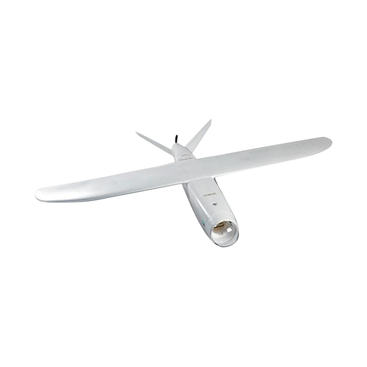
The M1 is a lightweight, high-performance fixed wing UAV for mapping designed for precision surveying.
Performance Highlights
- 120 km maximum distance
- 60-minute endurance
- 20 m/s cruise speed
- 5000 m altitude capability
- 1 kg payload (supports RTK/PPK/LiDAR)
Power & Control Systems
- 16,000mAh 6S LiPo battery (industrial-grade)
- 15 km controller range
- Dual 18650 controller power architecture
- 5 km HD FPV system
The Moneypro M1 is ideal for agriculture analytics, environmental monitoring, emergency response, and terrain surveying where portability and efficiency matter.
Top 8 Fixed Wing UAV for Mapping (2025 Ranking)
This list evaluates UAVs based on range, flight endurance, payload compatibility, stability, and mapping accuracy. The keyword “fixed wing UAV for mapping” is naturally integrated throughout to maintain SEO best practices.
1. ChinaMoneypro Spring Knife
A robust, large-payload fixed wing UAV engineered for high-speed, long-distance mapping missions.
2. ChinaMoneypro M1
A compact but powerful platform optimized for surveying accuracy with RTK/PPK-ready architecture.
3. WingtraOne GEN II
A vertical take-off fixed-wing hybrid known for Swiss-grade reliability and precision photogrammetry.
4. SenseFly eBee X
A legendary mapping platform widely used for commercial surveying worldwide.
5. Quantum Systems Trinity F90+
Hybrid VTOL with strong endurance and multisensor payload compatibility.
6. Autel Alpha EVO Fixed-Wing
Long-distance operations with enterprise-grade imaging sensors.
7. UX11 by Delair
French-engineered mapping drone with exceptional communication range and cloud integration.
8. Atmos Marlyn Cobalt
Designed for high-wind regions, ideal for coastal mapping and environmental monitoring.
Comparison Table: Top Fixed Wing UAV for Mapping
| Model | Endurance | Max Range | Payload | Key Feature |
|---|---|---|---|---|
| Moneypro Spring Knife | 60+ min | 120 km+ | 4.5 kg | High-speed, industrial-grade design |
| Moneypro M1 | 60 min | 120 km | 1 kg | Lightweight, RTK/PPK-ready |
| WingtraOne GEN II | 59 min | ~45 km | Various sensors | VTOL hybrid |
| eBee X | 90 min | 40 km | Up to 1.5 kg | Ultra-light portability |
| Trinity F90+ | 90 min | 100 km | 700 g | High stability VTOL |
| Autel EVO Fixed-Wing | 60 min | 70 km | 1 kg | High-res imaging suite |
| Delair UX11 | 59 min | 50 km | 750 g | Long-range communication |
| Marlyn Cobalt | 60 min | 30–40 km | Standard payload | Wind-resistant design |
Frequently Asked Questions
1. Why is a fixed wing UAV better for mapping than a multirotor drone?
Fixed-wing UAVs deliver longer endurance, higher speeds, and larger area coverage, making them ideal for surveys covering more than 2 km² per flight.
2. How do I choose the right fixed wing UAV for mapping?
Key factors include endurance, payload support (camera, LiDAR, multispectral), wind performance, RTK/PPK options, and communication range.
3. Can fixed wing UAVs operate in mountainous areas?
Yes. Many models, including the Moneypro M1 and Spring Knife, support operational ceilings above 3000–5000 m.
4. Which industries benefit most from fixed wing UAV mapping?
Construction, mining, power-line inspection, agriculture, environmental monitoring, and public safety.
References