Main Features
1. Support for Orthophoto, DLG, and Oblique Photogrammetry
The system supports orthophoto imaging, DLG (Digital Line Graph), and oblique photogrammetry workflows, making it suitable for a wide range of mapping and surveying applications. Whether you are conducting terrain mapping, urban modeling, or infrastructure inspection, this solution ensures high-precision data acquisition.
Key Benefits:
- Compatible with multiple aerial surveying methods
- Suitable for 2D mapping and 3D modeling
- High-precision data collection
- Ideal for professional surveying projects
2. Simplified Intelligent Flight Planning
The platform features an ultra-simple intelligent flight planning system that allows users to create professional aerial survey missions quickly and efficiently. Even beginners can easily set up complex missions with minimal configuration.
Key Benefits:
- Easy-to-use interface
- Automated mission generation
- Reduced setup time
- Improved operational efficiency
3. Automatic Multi-Layer Flight Route Planning
The system automatically generates multi-layer flight routes based on terrain elevation and mission requirements. This ensures consistent ground sampling distance (GSD) and improved data accuracy.
Key Benefits:
- Automatic altitude adjustment
- Consistent data quality
- Suitable for complex terrain
- Improved mapping accuracy
4. 3D Terrain-Following Flight
The 3D terrain-following flight mode allows the drone to fly along terrain contours, maintaining consistent altitude above ground level. This ensures better image overlap and higher data accuracy, especially in mountainous areas.
Key Benefits:
- Accurate terrain-following
- Better image overlap
- Improved data quality
- Ideal for mountainous areas
5. One-Click Corridor Mapping Mission
With one-click corridor mission generation, users can easily create mapping routes for linear projects such as roads, pipelines, railways, and power lines.
Key Benefits:
- Fast corridor mission setup
- Ideal for infrastructure inspection
- Automatic route generation
- Increased efficiency
6. Resume Flight After Power Loss
The power-loss resume function ensures that missions can continue seamlessly after interruptions such as battery replacement or unexpected shutdowns.
Key Benefits:
- Resume from breakpoint
- Prevent data loss
- Save flight time
- Improve workflow continuity
7. Multiple Terrain Collision Warnings and Safety Checks
The system includes multiple terrain collision warnings and intelligent safety checks to ensure safe flight operations. These features help prevent crashes and improve operational reliability.
Key Benefits:
- Mountain collision warning
- Terrain safety detection
- Intelligent risk alerts
- Enhanced flight safety
Ideal Applications
- Aerial Surveying
- Mapping and GIS
- Urban 3D Modeling
- Infrastructure Inspection
- Mining and Construction
- Agriculture and Land Survey
- Power Line and Pipeline Inspection
Why Choose This Solution
- Intelligent automation
- Professional mapping accuracy
- Easy operation
- Enhanced safety
- Efficient mission planning
This intelligent aerial survey planning solution helps professionals complete complex mapping missions faster, safer, and more accurately.
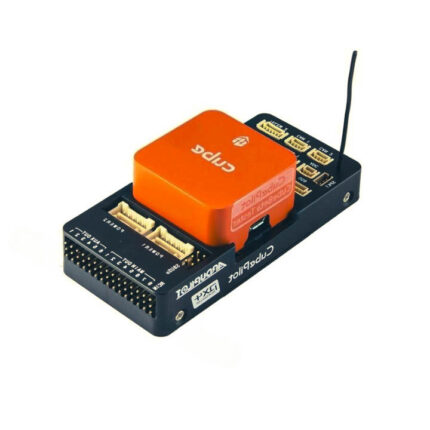
| Item | Specification |
|---|---|
| IMU Sensor | 1 |
| GPS Quantity | 1 |
| Power Supply | 8~60V |
| Operating Temperature | -20~+55 °C |
| Built-in IMU Shock Absorption | × |
| Built-in RTK | × |
| Built-in Dual Antenna Heading | × |
| Gimbal (Seeker) Support | × |
| Gasoline Engine Support | × |
| Airspeed Measurement Method | Single Dynamic Pressure |
| Power Consumption | <3W |
| Attitude Accuracy | 1° |
| Heading Accuracy | 2° |
| Gyroscope Range | ±450 °/s |
| Acceleration Range | ±8g |
| Positioning Accuracy | 2.5 m |
| Velocity Accuracy | 0.1 m/s |
| Airspeed Range | 0~40 m/s |
| PWM Channels | 14 Channels |
| SBUS Channels | 1 Input |
| Voltage Monitoring Channels | 2 Channels |
| Voltage Monitoring Range | 0~60V (Optional High Voltage Module) |
| CAN Interface | 1 |
| Serial Ports | 3 TTL |
| Ethernet | 0 |
| Dimensions | 82 × 62 × 19 mm |
| Weight | 92 g |