Product Features
Default outputs include:
- 3-axis angular rate
- 3-axis acceleration
- 3-axis inclination
- Temperature data
Applications
- Precision guidance and stabilization systems
- Downhole drilling and borehole surveying
- Fire control and defense-grade navigation systems
- UAVs and autonomous driving platforms
- Industrial robotics and automated measurement
- Satellite antenna stabilization
- Mapping and surveying systems
- Port measurement and monitoring systems
- Oil drilling and exploration platforms
- Lidar and laser measurement systems
Performance Specifications
| Parameter | Specification |
| General | |
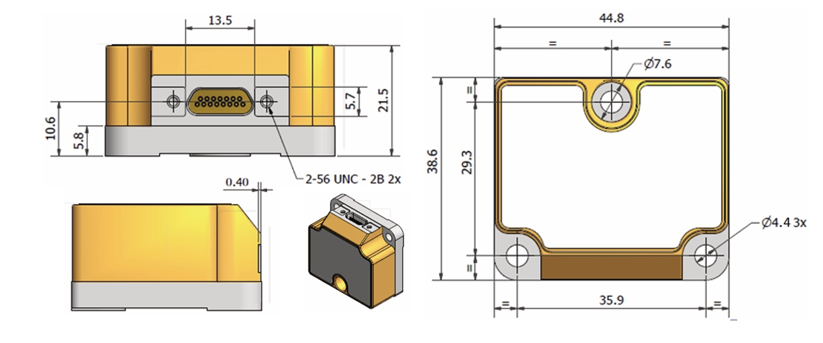
| Weight | 55 g |
| Startup Time | 3 s |
| Shock Resistance | 1500 g |
| Data Latency | 1.6 ms |
| Output Rate | 125 Hz – 2000 Hz |
| Bandwidth (–3 dB) | 16 Hz – 262 Hz |
| RS422 Bit Rate | Up to 921,600 Mbit/s |
| Environmental | |
| Operating Temperature | –40 °C ~ +85 °C |
| Storage Temperature | –50 °C ~ +90 °C |
| Power | |
| Supply Voltage | 4.5 – 5.5 V (typ. 5 V) |
| Power Consumption | 1.5 W (typ.) / 2.0 W (max) |
| Gyroscope Performance | |
| Measurement Range | ±400 °/s |
| Bias Instability | 0.3 °/h |
| Bias Repeatability | 0.22 °/h |
| Angular Random Walk | 0.15 °/√h |
| Scale Factor Nonlinearity | ±500 ppm |
| Nonlinearity | 15 ppm (±200 °/s) |
| Accelerometer Performance | |
| Measurement Range | ±10 g (up to ±80 g optional) |
| Bias Instability | 0.04 mg |
| Bias Repeatability | ±2 mg |
| Random Walk | 0.07 m/s/√h |
| Resolution | 1.9 μg |
| Scale Factor Nonlinearity | ±500 ppm |
| Inclinometer Performance | |
| Range | ±5 g |
| Resolution | 0.2 μg |
| Bias | 1.7 g |
| Scale Factor Nonlinearity | ±500 ppm |
Key Benefits
- Ultra-lightweight (55 g)for easy integration in UAVs, robotics, and portable navigation systems
- Tactical-grade performancewith bias instability as low as 0.3 °/h
- High sampling rate up to 2000 Hzwith ultra-low latency (1.6 ms)
- Magnetic field immunity, ensuring stable operation in challenging environments
- Fully configurableoutputs for flexible integration into custom platforms
Q1: What makes China Moneypro MP-IM003 different from other MEMS IMUs on the market?
A1: China Moneypro MP-IM003 is a tactical-grade MEMS IMU weighing only 55 g, making it one of the lightest high-performance IMUs available. Unlike standard MEMS IMUs, it delivers bias instability as low as 0.3 °/h, ultra-low random walk (0.15 °/√h), and high sampling rates up to 2000 Hz—features typically found in much larger and heavier systems.
Q2: Why is China Moneypro MP-IM003 ideal for UAVs, drones, and robotics?
A2: Its ultra-lightweight design (55 g) combined with low power consumption (1.5 W) makes China Moneypro MP-IM003 perfect for UAV navigation, drone stabilization, and autonomous robotics. The high dynamic range (±400 °/s, up to ±80 g accelerometer range) ensures precise navigation even in aggressive maneuvers and vibration-heavy environments.
Q3: How does China Moneypro MP-IM003 perform in magnetically disturbed environments?
A3: China Moneypro MP-IM003 is immune to magnetic interference, ensuring stable and reliable operation even in environments where magnetometers fail. This makes it highly suitable for industrial drilling, underground mapping, naval applications, and defense platforms.
Q4: Can China Moneypro MP-IM003 be customized for different applications?
A4: Yes. China Moneypro MP-IM003 allows flexible configuration of output format, data rate (125–2000 Hz), filters, and packaging, giving system integrators full control. Whether used in precision agriculture, surveying, downhole drilling, or defense-grade stabilization systems, China Moneypro MP-IM003 adapts seamlessly to different requirements.
Q5: What are the key industries and applications where China Moneypro MP-IM003 is widely used?
A5: China Moneypro MP-IM003 is deployed across a wide range of high-demand industries, including:
- Aerospace & UAVs – drone navigation and aerial mapping
- Defense systems – fire control, targeting, and tactical navigation
- Industrial robotics – precision measurement and motion control
- Oil & Gas – downhole drilling and wellbore surveying
- Geospatial & Surveying – mapping, stabilization, and LiDAR integration