Unmanned System Products
Showing 568–576 of 1477 results
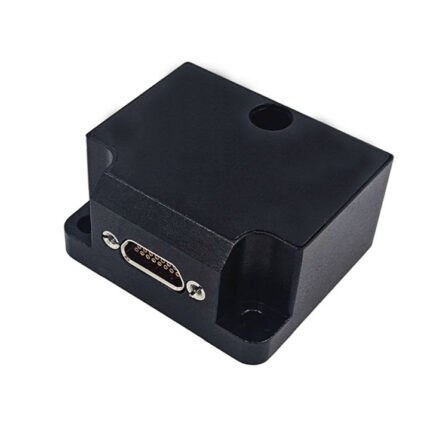
China Moneypro MP-VG2301 Vertical MEMS Gyroscope IMU
China Moneypro MP-VG2301 is a high-performance, cost-effective, compact, and lightweight vertical gyroscope inertial measurement unit (IMU). With low power consumption and full-temperature calibration, it provides accurate measurements of roll, pitch, angular velocity, and acceleration, even in harsh environments.
Equipped with 100% domestically produced components, the MP-VG2301 ensures long-term reliability and precision, making it an ideal choice for aerospace, defense, maritime, and industrial navigation systems.
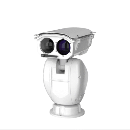
China Moneypro MPC464A1 Dual-Spectrum PTZ Camera
China Moneypro MPC464A1 is a dual-spectrum PTZ camera system designed for vehicle- and ship-mounted applications. It integrates visible light and infrared thermal imaging, with advanced AI recognition, auto-tracking, and optional laser ranging. The system adopts a three-axis gyro-stabilized platform, offering exceptional anti-vibration performance and long-term reliability in harsh environments such as high-salt and high-humidity conditions. It supports external cueing (radar, AIS) and provides all-weather, 24/7 search, monitoring, and tracking capabilities.
China Moneypro MPS196 Next-Generation SAR Reconnaissance Synthetic Aperture Radar Payload Systems
At China MoneyPro, we specialize in the custom design and development of Synthetic Aperture Radar (SAR) systems, delivering solutions that represent the cutting edge of global radar technology. Our mission is to help clients achieve unmatched imaging, detection, and reconnaissance performance under the most challenging
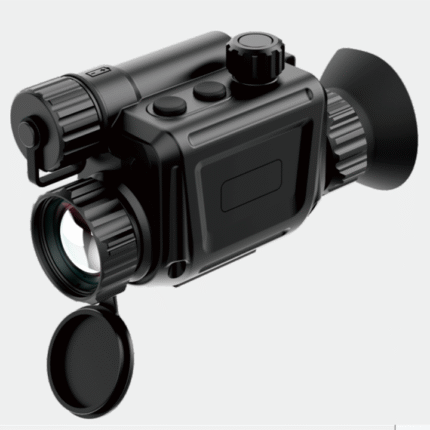
China Moneypro MPS630 Miniature Dual-Purpose Thermal Sight
China Moneypro MPS630 is a miniature dual-purpose thermal sight designed to operate in complete darkness, smoke, and dust. It can be used as a standalone weapon sight or paired with a day optic to enhance aiming accuracy. An intuitive scroll-wheel UI enables quick switching among handheld, gunsight co-work, and helmet modes, significantly improving the effectiveness of individual operators in all-weather, all-terrain missions.
Rugged, lightweight, and highly adaptable, China Moneypro MPS630 is suitable for military, law-enforcement, counter-terrorism, and search-and-rescue applications, offering advanced tactical performance backed by reliable engineering.
China Moneypro MPS645 Dual-Band Co-Path Thermal Sight
China Moneypro MPS645 is the world’s first thermal gun sight with dual-band common path design, holding an exclusive patent to ensure perfect alignment of visible light and infrared optical axes. It achieves true product miniaturization and lightweight integration while delivering uncompromised performance. Equipped with a third-generation 12µm / 640×512 infrared detector and a 2-megapixel HD visible light sensor, the MPS645 provides crystal-clear imaging and precise detail recognition under all weather and battlefield conditions, including total darkness, fog, smoke, and no-light environments.
Rugged, reliable, and easy to operate, the MPS645 is adaptable to various weapon platforms. It is ideal for military forces, law enforcement, counter-terrorism units, as well as civilian search & rescue missions, offering unmatched tactical advantages and advanced technical support.

China Moneypro MPS645-L Laser Thermal Gun Sight
China Moneypro MPS645-L integrates cutting-edge technologies including laser ranging, ballistic calculation, Wi-Fi transmission, and automatic photo/video recording at the moment of firing. Engineered for enhanced shooting accuracy and operational efficiency, the built-in Wi-Fi enables real-time image and data transfer to mobile devices, facilitating tactical analysis, team collaboration, and mission evaluation.
The system records each shot with video and photos, ensuring complete documentation of critical moments. Designed for versatility, durability, and ease of use, it can be mounted on multiple weapon platforms. MPS645-L is highly suitable for military, law enforcement, counter-terrorism, and civilian search and rescue missions.
China Moneypro MPS650 Lightweight Dual-FOV Multi-Purpose Thermal Sight
China Moneypro MPS650 is a distinguished multi-purpose thermal sight with dual-FOV gun sight design (WFOV & NFOV), engineered to enhance tactical performance and operational efficiency. Equipped with a high-resolution infrared sensor and intelligent image processing algorithms, it delivers crisp imaging and accurate target identification in real-time.
The Wide Field of View (WFOV) mode provides broader situational awareness, while the Narrow Field of View (NFOV) mode enhances accuracy for long-distance target acquisition. This dual-mode flexibility ensures operators can adapt seamlessly to varying tactical requirements.
Even in extreme conditions—complete darkness, heavy smoke, or challenging terrain—the MPS650 enables precise target detection and reliable imaging, ensuring mission success across military, law enforcement, counter-terrorism, and civilian applications.
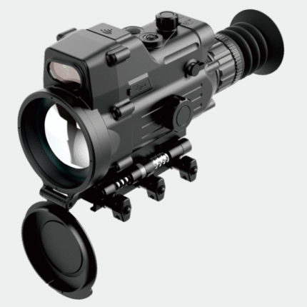
China Moneypro MPS670 Long Range Multi-Functional Thermal Sight
China Moneypro MPS670 is a multi-purpose thermal gun sight that integrates advanced technologies such as laser ranging, ballistic calculation, Wi-Fi transmission, and automatic video/photo recording at the moment of firing. Even in harsh environments such as total darkness or heavy smoke, it can accurately lock onto targets and provide crisp, high-resolution thermal imagery.
The high-precision laser ranging module provides real-time distance measurements, while the ballistic calculation system ensures highly accurate trajectories, significantly enhancing tactical performance.
Engineered with a rugged magnesium alloy housing and IP67 environmental protection, the MPS670 is designed for military, police operations, counter-terrorism actions, and civilian search-and-rescue missions, offering unparalleled technical support and tactical superiority.