🚨 Industry Pain Points
Modern navigation and positioning systems often face several challenges:
- Poor positioning accuracy in complex environments
- GPS signal loss or interference affecting navigation reliability
- Heading instability during low-speed or stationary conditions
- Temperature drift and sensor errors affecting long-term accuracy
- Limited integration capability with external sensors such as wheel encoders
- High dependency on satellite signals without inertial backup
These issues can significantly reduce system reliability and operational safety in professional applications.
⚙ Product Advantages
Our high-precision navigation system is designed to overcome these challenges with advanced technologies:
- ✔ Integrated MEMS Inertial Measurement Unit (IMU) and GNSS receiver
- ✔ MEMS temperature error compensation technology for improved stability
- ✔ System-level self-calibration and error compensation
- ✔ Dual-antenna heading output delay compensation and heading fusion
- ✔ INS/GNSS tightly coupled navigation filtering and sequential processing
- ✔ Online IMU non-orthogonality compensation
- ✔ Real-time output of position, velocity, and attitude information
- ✔ Supports external wheel speed sensor integration
- ✔ High reliability in GPS-denied or challenging environments
🚁 Product Applications
This navigation system is suitable for a wide range of professional applications:
- Unmanned aerial vehicles (UAVs)
- Autonomous ground vehicles (AGV / UGV)
- Marine navigation systems
- Robotics and automation systems
- Industrial equipment positioning
- Surveying and mapping platforms
- Intelligent transportation systems
Application Direction:
- Navigation
- Control
- Measurement
- Positioning and Orientation
⭐ Why Choose Us
- Advanced MEMS sensor fusion technology
- High accuracy and stability in harsh environments
- Strong anti-interference capability
- Flexible integration with external sensors
- Professional-grade navigation performance
- Customization support for various applications
- Reliable long-term operation
Our solution delivers high-precision navigation performance designed for demanding industrial and autonomous systems.
❓ Frequently Asked Questions (FAQ)
Q1: What navigation technologies does the system use?
The system uses MEMS IMU combined with GNSS and advanced sensor fusion algorithms.
Q2: Does the system support dual-antenna heading?
Yes, it supports dual-antenna heading output with delay compensation and fusion technology.
Q3: Can it operate without GPS signals?
Yes, the system supports inertial navigation and maintains operation during GPS signal loss.
Q4: Can external sensors be connected?
Yes, the system supports external wheel speed sensor input.
Q5: What parameters can the system output?
The system outputs real-time position, velocity, and attitude data.
| Parameter | unit | Type 1 | Type 2 | Type 3 | Type 4 | ||
| Aerial positioning accuracy (RMS) | path angle | ° | 0.1 (2m baseline) | ||||
| Pitch Angle / Roll Angle | ° | 0.2 | 0.1 | 0.08 | 0.05 | ||
| Position Precision (RMS) | horizontal | m | 1.5 (single point) (RTK: 0.8 cm + 1 ppm) | ||||
| altitude | m | 3 (Single point) (RTK: 1.5 cm + 1 ppm) | |||||
| Speed Precision (RMS) | m/s | 0.1 | |||||
|
gyroscope |
measuring range | ° /s | ±400 | ||||
| Zero offset stability (10-second smoothing, 1σ, room temperature) | ° /h | 10 | 3 | 1 | 0.4 | ||
| Full-temperature zero-drift variation (10-second smoothing, RMS, variable temperature) | ° /h | 60 | 20 | 10 | 2 | ||
| Zero bias repeatability | ° /h | 20 | 3 | 1 | 0.3 | ||
| random walk | ° / √ h | 0.5 | 0.15 | 0.05 | 0.02 | ||
| tape width | Hz | 250 | 150 | ||||
| The scaling factor is nonlinear. | ppm | 100 | |||||
| Scale factor repeatability | ppm | 100 | |||||
| cross coupling | % | 0.2 | 0.1 | ||||
|
accelerometer |
measuring range | g | ±10 | ||||
| Zero offset stability (10-second smoothing, 1σ, room temperature) | mg | 0.05 | |||||
| Full-temperature zero-drift variation (10-second smoothing, RMS, variable temperature) | mg | 2 | |||||
| Zero bias repeatability | mg | 0.2 | |||||
| tape width | Hz | 100 | |||||
| Scale factor repeatability | ppm | 500 | |||||
| cross coupling | % | 0.1 | |||||
|
satellite positioning |
frequency point |
—— |
BDS:B1IB2IB3IB1C B2a
GPS:LIC/A LIC L2P(W) L2CL5 GLONASS:L1L2 Galileo:E1 E5a E5b QZSS: L1 L2 L5 |
||||
| cold boot | s | 20 | |||||
| Data update rate | Hz | 100 (customizable) | |||||
| voltage | V | 9~36 | |||||
| power dissipation | W | ≤ 5 | |||||
| working temperature | ℃ | -45~80 | |||||
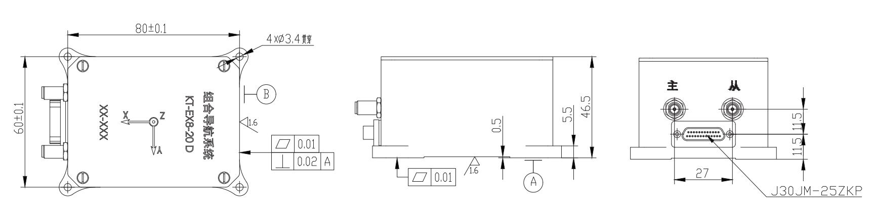
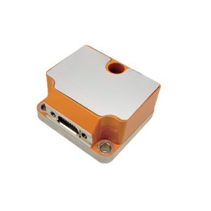
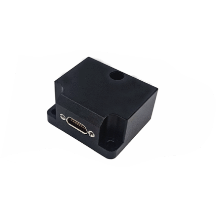
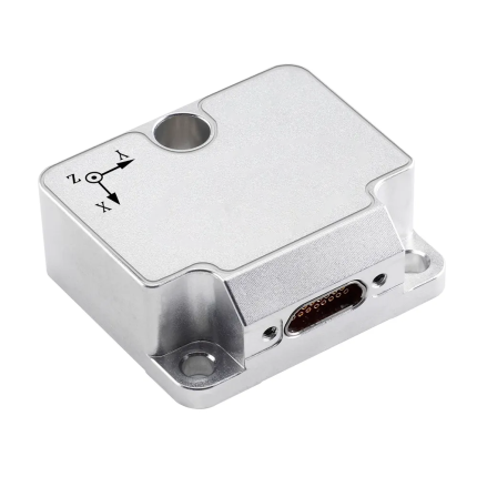
| size | mm | 88*68*46 | |||||
| weight | g | ≤ 300 | |||||
|
Interface |
—— |
2 RS-422/RS-232 channels (navigation output) 1 RS-232 channel (differential output)
1-channel PPS output 1 CAN output |
|||||