🚨 Industry Pain Points
In modern UAV, robotics, and autonomous vehicle applications, navigation systems often face critical challenges:
- GPS signal loss or degradation in urban canyons, tunnels, or dense environments
- Temperature drift affecting MEMS sensor accuracy
- Heading instability and slow response in dynamic conditions
- Poor integration between inertial and satellite navigation systems
- Accumulated positioning errors during long-duration operations
- Limited adaptability to complex environments and motion scenarios
These challenges reduce navigation accuracy, system reliability, and mission success rates.
⚙ Product Advantages
Our advanced navigation system is designed to overcome these limitations:
- ✔ High-precision MEMS inertial measurement unit (IMU) integration
- ✔ Built-in satellite positioning receiver for accurate global navigation
- ✔ MEMS temperature error compensation for stable performance
- ✔ System-level self-calibration and error compensation technology
- ✔ Dual-antenna heading output delay compensation and heading fusion
- ✔ INS/GNSS tightly-coupled navigation filtering and sequential processing
- ✔ Real-time IMU non-orthogonal compensation technology
- ✔ Outputs high-precision angular rate, acceleration, heading, attitude, velocity, and position data
- ✔ Supports external vehicle odometer for enhanced navigation accuracy
🚁 Product Applications
This high-precision navigation system is widely used in:
- Unmanned aerial vehicles (UAVs)
- Autonomous driving and intelligent vehicles
- Robotics and unmanned ground vehicles (UGV)
- Marine navigation and ship positioning
- Agricultural automation systems
- Industrial automation and mobile platforms
- Surveying and mapping systems
- Defense and security applications
⭐ Why Choose Us
- Advanced INS/GNSS tightly coupled navigation technology
- High reliability under complex and GPS-denied environments
- Aviation-grade sensor fusion algorithms
- Strong anti-interference capability
- High precision and long-term stability
- Flexible integration with multiple platforms
- Professional technical support and customization services
We provide professional-grade navigation solutions designed for high-precision and mission-critical applications.
❓ Frequently Asked Questions (FAQ)
Q1: What data does the system output?
The system outputs angular rate, acceleration, heading, attitude, velocity, and position data in real time.
Q2: Does it support dual-antenna heading?
Yes, the system supports dual-antenna heading output and fusion technology.
Q3: Can it work when GPS signals are weak?
Yes, the INS/GNSS tightly-coupled navigation allows stable performance in weak GPS environments.
Q4: Does the system support external sensors?
Yes, it supports external vehicle odometer integration for improved accuracy.
Q5: What applications is this system suitable for?
It is suitable for UAVs, autonomous vehicles, robotics, marine navigation, and industrial automation platforms.
| Parameter | unit | Type 1 | Type 2 | Type 3 | Type 4 | ||
| Aerial positioning accuracy (RMS) | path angle | ° | 0.1 (2m baseline) | ||||
| Pitch Angle / Roll Angle | ° | 0.2 | 0.1 | 0.08 | 0.05 | ||
| Position Precision (RMS) | horizontal | m | 1.5 (single point) (RTK: 0.8 cm + 1 ppm) | ||||
| altitude | m | 3 (Single point) (RTK: 1.5 cm + 1 ppm) | |||||
| Speed Precision (RMS) | m/s | 0.1 | |||||
|
gyroscope |
measuring range | ° /s | ±400 | ||||
| Zero offset stability (10-second smoothing, 1σ, room temperature) | ° /h | 10 | 3 | 1 | 0.4 | ||
| Full-temperature zero-drift variation (10-second smoothing, RMS, variable temperature) | ° /h | 60 | 20 | 10 | 2 | ||
| Zero bias repeatability | ° /h | 20 | 3 | 1 | 0.3 | ||
| random walk | ° / √ h | 0.5 | 0.15 | 0.05 | 0.02 | ||
| tape width | Hz | 250 | 150 | ||||
| The scaling factor is nonlinear. | ppm | 100 | |||||
| Scale factor repeatability | ppm | 100 | |||||
| cross coupling | % | 0.2 | 0.1 | ||||
|
accelerometer |
measuring range | g | ±10 | ||||
| Zero offset stability (10-second smoothing, 1σ, room temperature) | mg | 0.05 | |||||
| Full-temperature zero-drift variation (10-second smoothing, RMS, variable temperature) | mg | 2 | |||||
| Zero bias repeatability | mg | 0.2 | |||||
| tape width | Hz | 100 | |||||
| Scale factor repeatability | ppm | 500 | |||||
| cross coupling | % | 0.1 | |||||
|
satellite positioning |
frequency point |
—— |
BDS:B1IB2IB3IB1C B2a
GPS:LIC/A LIC L2P(W) L2CL5 GLONASS:L1L2 Galileo:E1 E5a E5b QZSS: L1 L2 L5 |
||||
| cold boot | s | 20 | |||||
| Data update rate | Hz | 100 (customizable) | |||||
| voltage | V | 9~36 | |||||
| power dissipation | W | ≤ 8 | |||||
| working temperature | ℃ | -45~80 | |||||
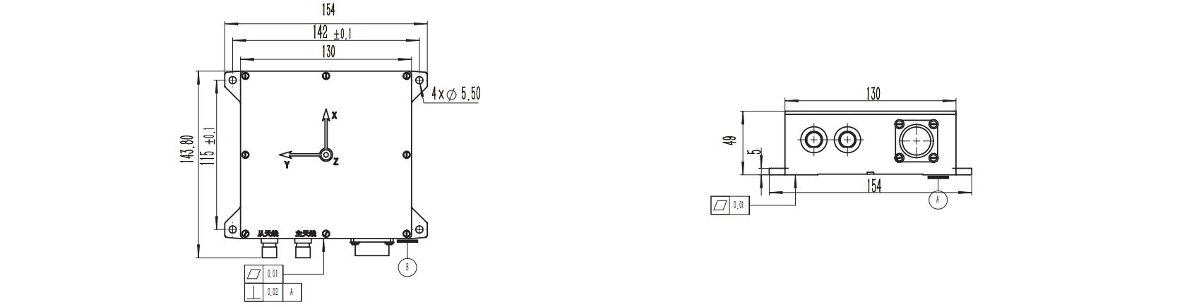
| size | mm | 143.8*154*49 | |||||
| weight | g | ≤ 1200 | |||||
|
Interface |
—— |
2 RS-422/RS-232 channels (navigation output) 1 RS-232 channel (differential output)
1-channel PPS output 1 CAN output |
|||||